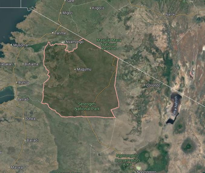
The Serengeti National Park, located in northern Tanzania and extending to the border with Kenya, is one of the world’s most renowned wildlife conservation areas. The park forms a key part of the Serengeti-Mara ecosystem, which is famous for the Great Migration—a mass movement of millions of wildebeest, zebras, and other animals between the Serengeti and Kenya’s Masai Mara. The park covers a vast area, and understanding its layout helps visitors plan their safaris efficiently.
Serengeti National Park Map
Navigating through the vast expanse of Serengeti requires a good understanding of its layout. The park covers approximately 14,750 square kilometers, with diverse landscapes ranging from savannahs to woodlands, rivers, and hills. A detailed map of Serengeti National Park highlights key regions, important landmarks, and the best wildlife viewing areas. The park is divided into several regions, each offering distinct ecosystems and wildlife experiences, from the endless plains in the southeast to the hilly, wooded northern sections.
The Vastness of the Serengeti: A Technical Exploration
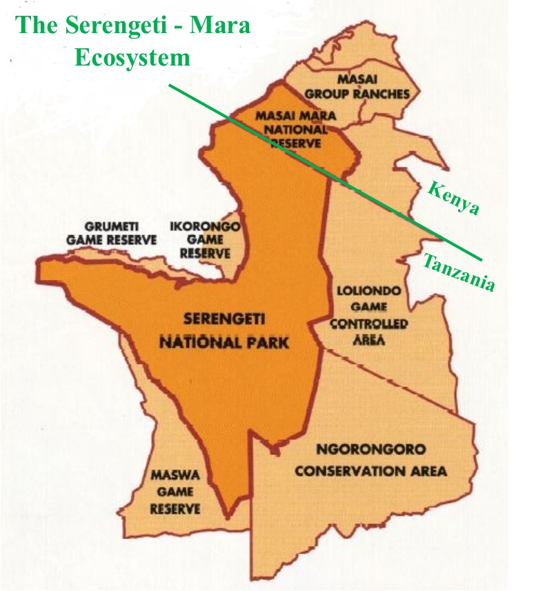
The Serengeti ecosystem, stretching across approximately 30,000 square kilometers (11,583 square miles), is one of the largest and most diverse wildlife areas in the world. It spans across two countries—Kenya and Tanzania—forming a transboundary ecosystem that includes the Maasai Mara Game Reserve in Kenya and the Serengeti National Park in Tanzania. This vast expanse supports one of the highest concentrations of large mammals on Earth and serves as a critical habitat for the annual Great Migration, a natural spectacle unlike any other.
Geographical Scope of the Serengeti Ecosystem
Serengeti National Park (Tanzania)
- Size: Approximately 14,750 square kilometers (5,700 square miles).
- Location: Situated in northern Tanzania, the park forms the core of the Serengeti ecosystem. It lies at an altitude that ranges from 920 meters to 1,850 meters (3,020 to 6,070 feet), resulting in diverse microclimates.
- Boundaries:
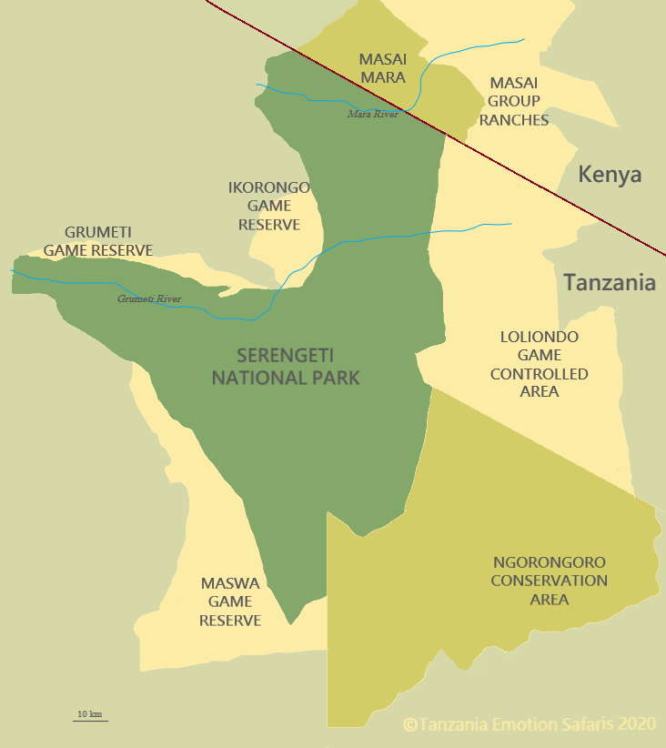
- To the southeast, it borders the Ngorongoro Conservation Area.
- To the west, the park is flanked by the Grumeti Game Reserve and the Ikorongo Controlled Area.
- To the north, it connects with Kenya’s Maasai Mara Game Reserve, allowing the Great Migration to flow uninterrupted across international borders.
Maasai Mara Game Reserve (Kenya)
- Size: Approximately 1,510 square kilometers (583 square miles).
- Location: The Maasai Mara is the northern extension of the Serengeti ecosystem, where a significant part of the Great Migration takes place between July and October.
The continuity of these regions allows for the free movement of wildlife across borders, maintaining the integrity of the ecosystem and supporting the extensive migratory patterns of herbivores such as wildebeest and zebras.
Geological Features of the Serengeti
Topography and Plains
- The Serengeti is characterized by its vast, rolling plains, which are primarily composed of volcanic soil deposited from the nearby Ngorongoro Highlands. The fertile volcanic ash that blankets the Serengeti plains creates ideal conditions for the growth of short grasses that support large populations of grazing animals.
- The open plains, especially in the southern and central regions, are flat, allowing for unobstructed views across the landscape. These areas are known for their short grass savannahs, which serve as prime grazing grounds for herbivores during the rainy seasons.
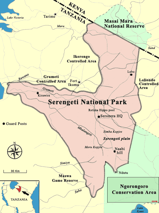
Kopjes (Rock Outcrops)
- Scattered throughout the Serengeti plains are kopjes, ancient granite rock formations that date back over 500 million years. These rock outcrops provide shelter for a variety of wildlife, including lions, leopards, and smaller creatures like hyraxes.
- The Moru Kopjes in central Serengeti are among the most famous and are often visited by safari-goers. Kopjes serve as vantage points for predators scouting for prey, making them a key feature of the park’s landscape.
Rivers and Water Sources
- The Serengeti is home to several key rivers, including the Mara River, the Grumeti River, and the Mbalageti River. These rivers are essential for sustaining wildlife, especially during the dry season.
- The Mara River is perhaps the most famous, as it forms the setting for the dramatic river crossings during the Great Migration. Wildebeest and zebras cross the river as they migrate between Tanzania and Kenya, facing predators like crocodiles that lie in wait.
- The Grumeti River, located in the western corridor, is another critical water source. It provides refuge for animals during the dry season and is also famous for the migration crossings that occur here in May and June.
Serengeti Ecosystems
The Serengeti ecosystem is composed of a variety of distinct habitats, each supporting a different community of wildlife. These habitats range from expansive grasslands to dense woodlands, riverine forests, and seasonal wetlands. Each ecosystem plays a crucial role in maintaining the biodiversity of the region.
1. Grasslands and Savannahs
- Short Grass Savannahs: Found primarily in the southern and central Serengeti, these grasslands are the prime grazing grounds for herbivores such as wildebeest, zebras, and gazelles. The short grasses make it easier for predators such as lions and cheetahs to hunt.
- Long Grass Savannahs: Located more toward the western Serengeti and parts of the north, these areas are less populated but serve as refuge areas for elephants, giraffes, and buffalo.
2. Woodlands
- Acacia Woodlands: Scattered across the Serengeti, especially in the central and northern regions, acacia woodlands offer shade and shelter to various species, including elephants, giraffes, and leopards. They also provide nesting sites for a wide range of bird species.
- Riverine Forests: These forests are concentrated along the banks of the Serengeti’s rivers, such as the Mara and Grumeti Rivers. Riverine forests provide critical habitats for species like hippos, crocodiles, and many bird species.
3. Kopjes Ecosystem
- Kopjes support unique plant and animal species due to the microhabitats they create. The rock formations collect water during rains, supporting hardy vegetation and providing shelter for reptiles and small mammals.
Climate and Weather Patterns
The climate of Serengeti is dictated by the region’s distinct wet and dry seasons, with the two rainy periods (long rains from March to May and short rains in November) driving the migratory patterns of many species.
Dry Season (June to October)
- The dry season is characterized by cooler temperatures and little rainfall. During this period, water becomes scarce, and animals congregate around rivers and permanent water sources.
- This is also the time when the migration reaches the northern Serengeti and the Mara River, offering some of the most dramatic wildlife spectacles.
Wet Season (November to May)
- The long rainy season from March to May replenishes the grasslands, triggering the Great Migration as the wildebeest and zebras follow the rains in search of fresh grazing grounds. This is the best time to witness the birth of thousands of calves in the southern Serengeti.
- Floodplains and seasonal rivers come to life during the wet season, providing ample water for the wildlife to thrive.
Conservation and Wildlife Management
Serengeti’s wildlife faces a number of threats, including poaching, habitat loss, and human-wildlife conflict. Conservation efforts are focused on protecting this unique ecosystem through a variety of methods.
Anti-Poaching Patrols
- Anti-poaching patrols work tirelessly to protect elephants, rhinos, and other species targeted by poachers. Ranger patrols and surveillance technologies such as drones and satellite tracking have helped curb illegal hunting.
Habitat Restoration and Rewilding
- Projects aimed at restoring degraded habitats, such as riverine forests and savannahs, are critical for maintaining the balance of the ecosystem. Rewilding projects also focus on reintroducing species into areas where they have disappeared.
Climate Change Mitigation
- Sustainable land management and wildlife corridor creation are key to ensuring species can adapt to changing climatic conditions. Wildlife corridors allow animals to migrate safely between protected areas, especially as their traditional routes are altered by climate change.
Conclusion
The Serengeti ecosystem is one of the world’s most biodiverse and geographically varied regions, supporting thousands of species across its vast plains, kopjes, rivers, and forests. Understanding the intricate details of Serengeti’s geography, ecosystems, and climate is key to appreciating the delicate balance that conservationists work to maintain. As a global heritage site, Serengeti continues to inspire efforts for wildlife conservation and sustainable tourism, ensuring that future generations can enjoy this magnificent natural wonder.
Key Regions and Boundaries
Serengeti’s National Park Main Boundaries
- Kenya Border: The northern boundary connects Serengeti to Masai Mara National Reserve in Kenya. This shared ecosystem is crucial for the annual Great Migration.
- Ngorongoro Conservation Area: To the southeast lies the Ngorongoro Conservation Area, another UNESCO World Heritage site, known for its iconic crater and dense wildlife.
- Game Reserves: Serengeti is flanked by important reserves like the Grumeti Game Reserve and Ikorongo Game Reserve to the west, both of which play vital roles in protecting the migratory routes of wildlife.
Conservation Areas
- Lobo and Loliondo: The Lobo area in the northern Serengeti extends toward the Loliondo Game Controlled Area, a buffer zone where Maasai communities live harmoniously with wildlife.
- Grumeti Game Reserve: Located in the west, this reserve is crucial for the migration of wildebeest and zebras as they move toward Kenya.
Geographical Landmarks
Serengeti Plains
- The Serengeti Plains dominate the southern and central regions of the park, offering vast open grasslands that are ideal for spotting the wildlife migration. The short grass plains make it easier for predators such as cheetahs and lions to hunt prey.
Hills and Kopjes
- Lobo Hills: Found in the northern section, these hills provide refuge for wildlife during the dry season. Their rugged terrain is covered in woodlands.
- Moru Kopjes: Situated in the central Serengeti, these granite outcrops serve as natural observation posts for predators like lions. They are also home to ancient Maasai rock art.
Rivers and Lakes
- Mara River: Located in northern Serengeti, the Mara River is famous for the dramatic river crossings during the migration. Crocodiles often lie in wait as herds of wildebeest and zebras attempt to cross.
- Grumeti River: Situated in the western corridor, this river is another critical point in the migration. It is home to some of Africa’s largest crocodiles and pods of hippos.
- Lake Ndutu: In the southern part of the park, this seasonal lake is a hub of activity during the calving season from December to March.
- Lake Magadi: Near the Moru Kopjes, Lake Magadi is a fantastic spot for birdwatching, especially for flamingos.
Key Features of the Landscape
Altitude and Climate
- Altitude Range: Serengeti’s altitude varies from 920 meters (3,020 feet) in the lower plains to 1,850 meters (6,070 feet) in the hilly regions. The altitude influences both climate and vegetation across the park. Higher areas, like Lobo Hills, tend to be cooler and more forested, while the plains are hotter and more arid.
Topography
- Savannahs: The short grass plains in the south provide ample grazing land for herbivores, while the savannahs stretch into woodlands as you move westward and northward.
- Woodlands: Particularly prevalent in the western corridor and northern Serengeti, these woodlands provide critical shelter for species like elephants and leopards.
- Kopjes: The Moru Kopjes are unique geological features scattered throughout the park. They provide shelter to wildlife and serve as a natural vantage point for predators to scout for prey.
Navigating the Park
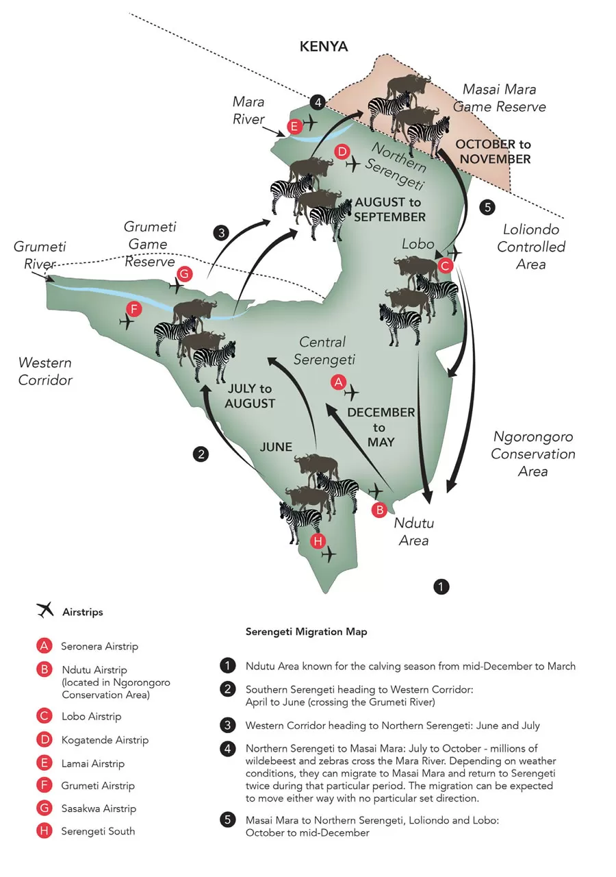
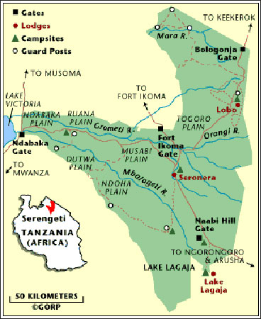
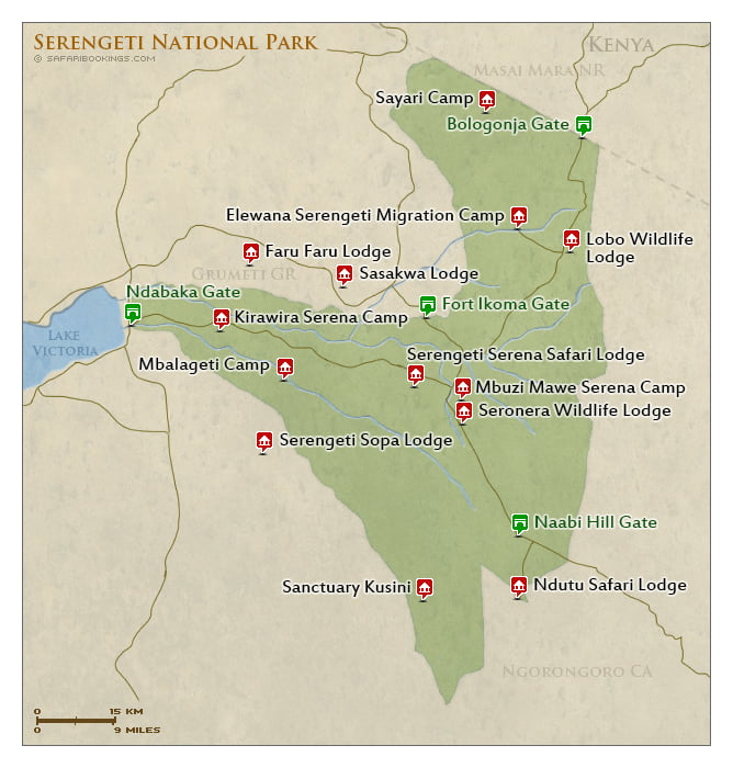
Major Airstrips
- Seronera Airstrip (A): Centrally located, this airstrip gives access to the heart of Serengeti, where wildlife sightings are almost guaranteed year-round.
- Kogatende Airstrip (D): Found in the northern Serengeti, near the Mara River, it is a popular entry point for those seeking to witness the dramatic river crossings during the Great Migration.
- Ndutu Airstrip (B): Located near the Ngorongoro border, this airstrip is key for accessing the Ndutu Area, known for its calving season.
Safari Regions
- Western Corridor: This remote section of Serengeti follows the Grumeti River, offering rich wildlife sightings and fewer tourists. It is a prime location for viewing the migration during the dry season.
- Central Serengeti (Seronera): The most popular area of the park due to its central location and diverse habitats, Seronera offers year-round wildlife viewing, from predators like lions and leopards to large herds of grazing animals.
- Northern Serengeti: Famous for the Mara River crossings, this region shares a boundary with Kenya’s Masai Mara and is one of the best places to witness the Great Migration in action from July to October.
Climate and Seasonal Movements
Wet and Dry Seasons
- Dry Season (June to October): Wildlife is concentrated around rivers and waterholes, making it the best time for game viewing. This period sees the famous Mara River crossings.
- Wet Season (November to May): Rain transforms the dry plains into lush green pastures, with southern Serengeti becoming a haven for migrating herds, particularly during the calving season in Ndutu.
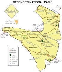
Key Regions and Boundaries
- Main Boundaries:
- Kenya Border: To the north, Serengeti borders Kenya’s Masai Mara National Reserve, marking an important boundary in the ecosystem, especially for the wildebeest migration.
- Ngorongoro Conservation Area: Serengeti’s southeast connects with the Ngorongoro Conservation Area, a UNESCO World Heritage site, and famous for its crater and rich wildlife.
- Game Reserves: To the west, Serengeti is bordered by Grumeti Game Reserve and Ikorongo Game Reserve.
- Conservation Areas:
- The Lobo Region in the northern part of the park extends toward the Loliondo Game Controlled Area, which serves as a buffer zone where local communities coexist with wildlife.
- The Grumeti Game Reserve in the west plays a crucial role in protecting the migration route.
- Key Airstrips:
- Seronera Airstrip (A): Located in Central Serengeti, it serves as the park’s main airstrip and offers access to the region known for its year-round wildlife.
- Ndutu Airstrip (B): In the southeastern part, adjacent to the Ngorongoro Conservation Area, offering access to the Ndutu calving grounds.
- Kogatende Airstrip (D): Situated in the northern Serengeti near the Mara River, a key area for viewing the migration crossings.
Geographical Landmarks
- Plains:
- The Serengeti Plains dominate the central and southeastern parts of the park. These plains are characterized by short grasses and vast open spaces, ideal for witnessing predator-prey interactions during the migration. The plains stretch into the Ngorongoro Conservation Area, making it part of the migration route.
- Hills:
- The Lobo Hills, located in northern Serengeti, are rugged and feature dense woodlands. These hills provide sanctuary for wildlife during the dry season when the plains are barren.
- Moru Kopjes: Located in central Serengeti, these rocky outcrops (kopjes) serve as resting spots for predators like lions and leopards. They also hold cultural significance with ancient Maasai rock paintings.
- Rivers:
- Mara River: In northern Serengeti, the Mara River is famous for the dramatic migration crossings. Crocodiles lie in wait as herds of wildebeest and zebras make their way through the water.
- Grumeti River: Running through the western corridor, the river supports a diverse range of wildlife, including large pods of hippos and crocodiles. The Grumeti plays an essential role during the migration season when animals cross it on their way north.
- Mbalageti River: Found in the western corridor, this river also supports abundant wildlife and is a key point during the migration.
- Lakes:
- Lake Ndutu: Situated in the southern part of the park, on the border with the Ngorongoro Conservation Area, Lake Ndutu is a seasonal lake that plays a critical role in the calving season from December to March.
- Lake Magadi: Located near the Moru Kopjes, this lake is a great spot for birdwatching, especially for flamingos.
Climate and Terrain
- Altitude and Climate:
- The park’s altitude ranges from 920 meters (3,020 feet) to 1,850 meters (6,070 feet) above sea level, affecting both the climate and the types of ecosystems within the park. The central regions tend to be hotter and more arid, while the higher northern areas are cooler and more verdant.
- Savannah and Woodlands:
- The central and southern Serengeti consists mostly of open savannahs, ideal for grazing animals such as wildebeest, zebras, and gazelles.
- As you move toward the western corridor and the northern regions, the landscape becomes more wooded, with patches of dense bush and acacia forests that provide shelter for species such as elephants and leopards.
Navigating the Park
- Western Corridor:
- The western part of Serengeti is less frequently visited but offers rich rewards for those looking to explore off the beaten path. It is here that the Grumeti River plays a pivotal role in the migration. The Grumeti Game Reserve is part of the corridor, and the region is home to iconic animals like elephants, giraffes, and large cats.
- Northern Serengeti:
- The northern region is home to the Mara River, where the famous river crossings take place. This area also shares a border with Masai Mara, making it an important extension of the migration route.
- Central Serengeti (Seronera):
- This region is the heart of the park, where most tourists begin their safari journey. The Seronera Valley has a mix of savannah and woodlands, which attract diverse species, including predators like lions, cheetahs, and leopards. It’s a year-round wildlife viewing hotspot.
Summary of Key Areas for Safari
- Ndutu Area (South): Known for its calving season, this is where much of the action occurs between December and March. Predators gather in large numbers to prey on vulnerable newborns.
- Western Corridor: This area is great for seeing the migration in the Grumeti River region, especially during the dry season (June to August).
- Northern Serengeti: The best place for witnessing the Mara River crossings during the migration’s movement into Kenya (July to October).
Size of Serengeti National Park
Serengeti National Park spans 14,750 square kilometers (5,700 square miles), making it one of the largest national parks in Africa. This vastness plays a crucial role in supporting the immense biodiversity within the park, including the world’s most famous wildlife spectacle: the Great Migration. The large size also allows for diverse climates, vegetation zones, and animal populations, from dense woodlands to open savannah plains.
Serengeti Plains
The Serengeti Plains form the heart of the park and are perhaps its most iconic landscape. Covering vast stretches of the southeastern Serengeti, these seemingly endless grasslands are where you’ll find the famous wildebeest migration in action. The plains are open, offering breathtaking views of animals roaming freely, including lions, zebras, and gazelles. This region is characterized by short grasses, which make it easier to spot predators like cheetahs hunting prey.
Regions of Serengeti National Park
Serengeti is divided into several distinct regions:
- Southern Serengeti: Known for the short grass plains where the Great Migration begins, this region offers excellent opportunities to witness calving season.
- Central Serengeti (Seronera Valley): Famous for year-round wildlife, this area has rivers and acacia woodlands, attracting big cats and elephants.
- Northern Serengeti: Rugged and more remote, this region offers dramatic landscapes and is where the wildebeest cross the Mara River.
- Western Corridor: Characterized by riverine forests and the Grumeti River, this region is known for hippos, crocodiles, and the migration crossing during the dry season.
Serengeti Ecosystems
Serengeti’s varied ecosystems contribute to its extraordinary wildlife diversity. The park has five key ecosystems:
- Grasslands: Home to the famous plains game, including wildebeest, zebras, and predators like lions and cheetahs.
- Woodlands: Found in the central and western regions, these areas provide cover for leopards and are favored by elephants.
- Rivers and Wetlands: Rivers such as the Grumeti and Mara are critical for providing water to animals during the dry season.
- Savannahs: The expansive savannahs are home to the bulk of grazing animals and their predators.
- Kopjes: Rocky outcrops that provide shelter for lions and are often referred to as “islands in a sea of grass.”
Landscape of Serengeti National Park
The landscape of Serengeti is a visual treat for safari-goers. Rolling plains, punctuated by ancient rock formations known as kopjes, give way to acacia woodlands, winding rivers, and misty hills. These diverse habitats are essential for the survival of the park’s wildlife, providing food, water, and shelter.
The kopjes are a distinctive feature of Serengeti’s landscape. These granite rock formations act as shelters for lions, leopards, and other predators, offering excellent viewing spots for safaris. The Seronera Valley is renowned for its year-round water supply, making it a critical habitat for wildlife.
Altitude of Serengeti
Serengeti’s altitude varies from 920 to 1,850 meters (3,020 to 6,070 feet) above sea level. This variation in altitude affects not only the climate but also the types of vegetation and wildlife found in different areas. The higher areas, such as the Lobo Hills in the north, tend to be cooler and more wooded, while the lower regions, like the plains, are warmer and open.
Topography of Serengeti
The topography of Serengeti is diverse, ranging from flat, open plains in the southeast to rolling hills in the north and west. This variation in elevation creates distinct habitats and influences animal movement. The Great Rift Valley forms the western edge of the park, adding dramatic escarpments and river valleys to the landscape. These physical features are crucial in creating migration routes and breeding grounds for various species.
Climate of Serengeti National Park
The climate in Serengeti is typically tropical, with distinct wet and dry seasons. The park experiences two rainy periods: the long rains from March to May and the short rains in November and December. The dry season, from June to October, is considered the best time for wildlife viewing, as animals congregate around water sources. The variation in rainfall across different regions also affects the vegetation, influencing where animals migrate throughout the year.
Savannahs of Serengeti
The savannahs of Serengeti are among the park’s most iconic landscapes. These open grasslands are where the Great Migration unfolds as millions of wildebeest and zebras move in search of fresh pastures. The savannahs are interspersed with acacia trees and provide the perfect habitat for predators such as lions and cheetahs, who rely on the open spaces for hunting. The short-grass savannahs in the southern part of the park offer excellent visibility for spotting wildlife.
Rivers of Serengeti
Serengeti’s rivers are the lifeblood of its ecosystems, especially during the dry season. The Mara River, located in the northern Serengeti, is famous for the dramatic crossings during the Great Migration. Here, wildebeest and zebras risk their lives to cross the crocodile-infested waters. The Grumeti River in the west also plays a crucial role during the migration, offering water to animals that move through the area during the dry season. These rivers support a wide range of species, including hippos, crocodiles, and various birdlife.
Hills of Serengeti
Serengeti’s hills, such as the Lobo Hills and Wogakuria Hills, are more rugged and provide a stark contrast to the flat plains. These areas are less frequented by tourists, offering a more remote safari experience. The hills are covered with woodlands, providing refuge for species like elephants and buffalo. The northern hills are particularly scenic, with panoramic views of the surrounding savannahs.
Conclusion
The geography of Serengeti National Park is as diverse as the wildlife it supports. From its vast plains and towering kopjes to its rolling hills and life-giving rivers, every element of Serengeti’s geography plays a crucial role in shaping the park’s unique ecosystems. Whether you’re drawn to the dramatic river crossings, the sweeping savannahs, or the serene woodlands, Serengeti offers an unparalleled opportunity to experience nature at its most raw and beautiful.
Understanding the park’s geography is key to planning the perfect safari, ensuring that you visit the right regions at the right times to maximize your wildlife viewing opportunities.